REVIEW · SANTO ANTAO
Santo Antão: Hike Ponta do Sol – Fontainhas – Cruzinha
Book on Viator →Operated by Bu Country Tours · Bookable on Viator
Black sand and cliff views in one hike. This 7-hour Santo Antão trek links Ponta do Sol to Fontainhas with a guide-led route so you don’t waste time second-guessing trails or missing viewpoints. You’ll also get private transportation built into the day, plus pickup from several spots around the island.
What I like most is how the hike mixes real village life with big ocean views. You move from a waterfront fishing village up to Fontainhas, then down through small settlements, with photo stops timed for those sea-facing angles.
One thing to consider: this is rated difficult, with a narrow start and real exposure. If heights make you uneasy, this isn’t the day for it, and you’ll want solid fitness for steep up/down segments.
In This Review
- Key things to know before you go
- Santo Antão’s cliff-to-village route: what this hike really feels like
- Price and value: what $91.15 buys you (and what it doesn’t)
- Morning logistics from 8:00 am: pickup, timing, and keeping the day smooth
- Ponta do Sol to Fontainhas: fishing village colors, cliff roads, and sea views
- The descent via Corvo, Formiguinhas, and Aranhas Village
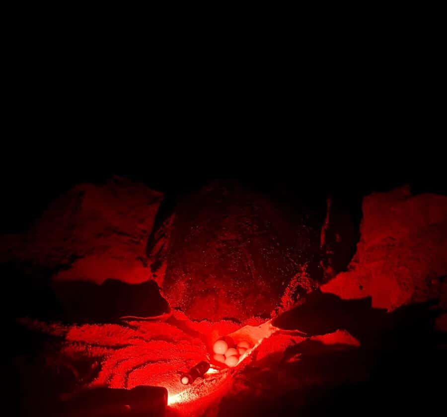
- Praia das Aranhas: black-sand turtle nesting country and optional swim time
- Cruzinha finish: volcanic rocks, ocean views, and a village ending
- What to bring for a difficult 15 km day
- Who should book this hike, and who should skip it
- Should you book this Santo Antão route?
- FAQ
- How long is the hike?
- What’s the distance and elevation change?
- Is pickup from my accommodation included?
- Is this a private tour?
- What time does the tour start?
- Is lunch included in the price?
- Is swimming possible at Praia d’Aranhas?
- What level of fitness is required?
- Is it safe for people afraid of heights?
- What’s the cancellation policy?
Key things to know before you go
- Pickup that keeps you from wrestling local transport before the walk even starts
- Fontainhas viewpoints reached via narrow mountain roads and cliffside walking
- Praia das Aranhas black-sand turtle nesting beach, with swimming only if sea conditions allow
- 15 km of linear trail that stays scenic without looping back on itself
- Difficult rating with ~249 m ascent/descent, so plan on serious legs
- Américo is a stand-out guide for Spanish and pacing, adjusting to your rhythm
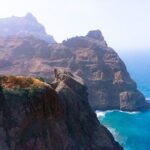
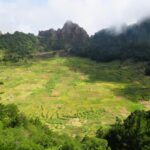
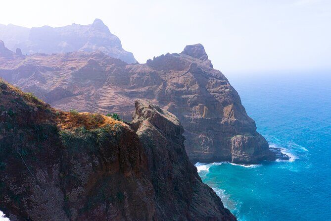
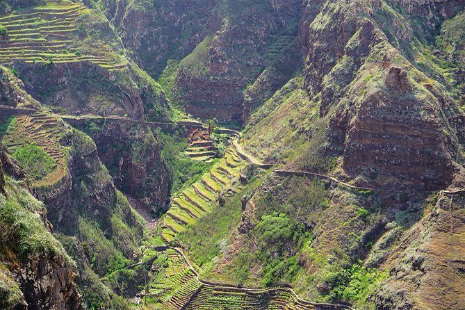
Santo Antão’s cliff-to-village route: what this hike really feels like
This hike is a full day of changing scenery: ocean edge, mountain valleys, and the kind of village-to-village walking that feels practical, not staged. You start in Ponta do Sol at 8:00 am, then gradually build into tougher terrain as you go up and down. The total walking time is about 6 hours within a roughly 7-hour experience, with a distance around 15 km.
Even with only ~249 m of ascent/descent listed, the trail still reads as “difficult” because of the way it’s laid out. Expect steep stretches, narrow segments at the beginning, and walking paths that don’t forgive sloppy footwear. If you’re the type who sweats the small stuff—shoe grip, balance, where to place your feet—this day rewards that attention.
I also like that the route is guided and linear. You’re not trying to stitch together viewpoints on your own. The guide’s job is to show the best route so you don’t get lost and you stay on track for the key visual moments, including the famous view area at Fontainhas and the black-sand beach later.
You can also read our reviews of more hiking tours in Santo Antao
Price and value: what $91.15 buys you (and what it doesn’t)
At $91.15 per person, the value is mostly in two things: guiding and private transportation. You’re not just buying “a walk.” You’re paying for a local guide to manage the route, keep you moving, and get you to the scenic beats efficiently.
Private transportation matters in Santo Antão because it reduces time spent figuring out how to reach each village point. It also helps the day end cleanly: after you reach Cruzinha, you return by transfer to your accommodation. That “start right / finish right” structure is part of why the hike works as a full-day plan.
What you’re not paying for is also important. Snacks aren’t included, and the picnic lunch is an extra cost. You might bring what you want for snacks, but the tour isn’t assuming you’ll be fueled all day without planning. If you hate carrying extra items, you’ll want to think ahead about how you’ll handle water, small energy food, and sun protection.
Morning logistics from 8:00 am: pickup, timing, and keeping the day smooth
The day starts at 8:00 am. That’s early enough to beat the worst sun and to get to Ponta do Sol while conditions are fresh. Pickup is offered from several spots in Santo Antão, and the experience includes private transportation, so you’re not relying on public transit once you commit.
There’s one catch: if your pickup location is in a remote area, an extra fee may apply. If you’re staying in a less central spot, it’s worth confirming pickup details before the day. Still, the tour is described as being near public transportation, which usually helps if you end up coordinating a meeting point on the fly.
Another practical detail: this is a private tour/activity, meaning only your group participates. That typically translates into a more flexible pace and fewer crowds around the views. One review specifically called out Américo adapting to the group’s rhythm without issues, which is exactly what you want on a difficult, mostly linear hike.
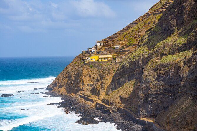
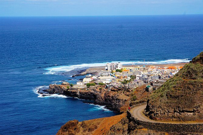
Ponta do Sol to Fontainhas: fishing village colors, cliff roads, and sea views
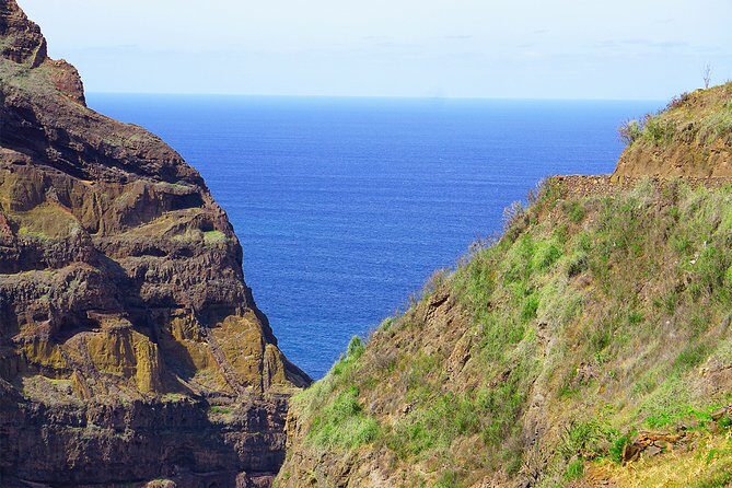
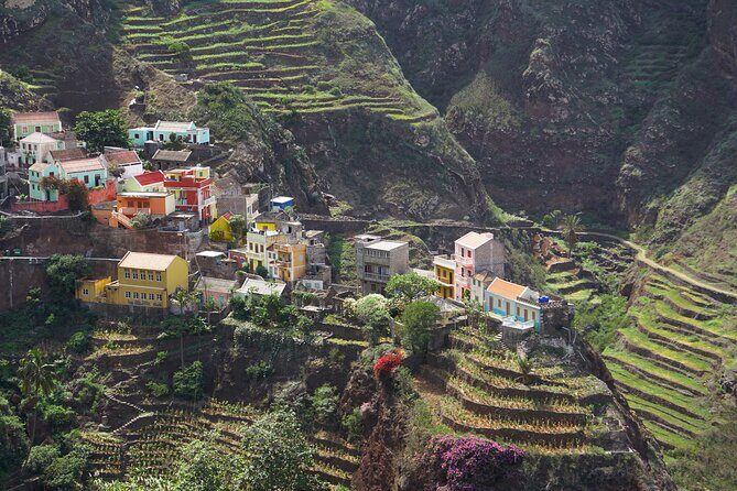
Ponta do Sol is your starting point, a waterfront fishing village with colorful houses. The first hour sets your tone: you walk from the sea edge and follow a road that rises along rocky cliffs above the ocean. It’s the kind of coastal route where you’ll want your camera ready—because the ocean view keeps changing as you gain height.
From there you head to Monte Fontainhas. This is where the terrain becomes more “mountain Santo Antão”: a small, sinuous road carved on top of a mountain, surrounded by deep valleys. The village of Fontainhas is known for its sweeping outlook—there’s a claim tied to National Geographic that it’s among the top view villages worldwide. Even if you don’t care about rankings, the function is what matters: you’re reaching an iconic viewpoint and then moving on.
The stop itself is short, so don’t plan on a long wandering session. Think of it as a photo + orientation moment: get your bearings, grab the angles, and trust the guide to keep you on the next leg.
My tip: if you’ve got a phone with low battery, charge it fully before you go. You’ll be stopping for views more than once, and you won’t want to fight the battery while the ocean does its thing.
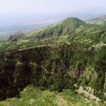
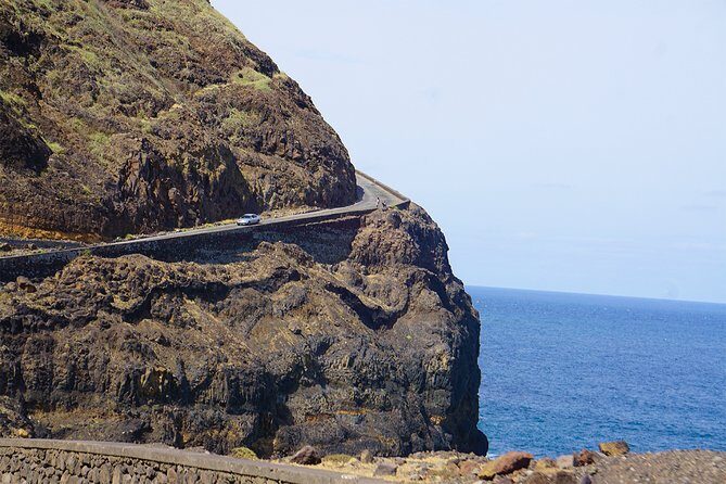
The descent via Corvo, Formiguinhas, and Aranhas Village
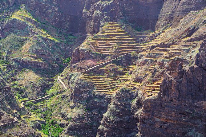
After Fontainhas, the hike turns into a steep descent. You follow a pedestrian path that crosses Corvo, Formiguinhas, and Aranhas Village. This portion is shorter on paper (about 30 minutes), but it can feel longer on your legs because downhill walking asks for good control.
It’s also the segment where you go from “high viewpoint” mode to “passing through settlements” mode. That change matters because it keeps the day varied. You’re not stuck staring at the ocean the whole time. You see how the villages connect along the mountain edge, and you’ll likely notice how the path weaves between places rather than cutting through empty terrain.
Path quality is described as linear, narrow at the beginning, and safe. Safe doesn’t mean easy. Narrow can still test your balance, especially if you’re tired or if the ground is uneven. Wear shoes with solid grip and a secure fit. Your feet need confidence more than they need fashion.
If you’re the one in your group who wants to move at a steady rhythm, this is where the guide’s pacing matters. The reviews highlight that Américo is experienced at adapting to the group’s pace, which helps a descent feel controlled instead of rushed.

Praia das Aranhas: black-sand turtle nesting country and optional swim time
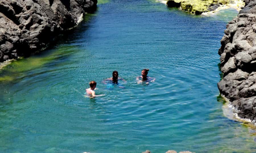
Next comes Praia d’Aranhas, the black-sand beach stop. This is a highlight for a reason: it’s a turtle nesting area, and you’re walking into a beach setting that feels different from the rest of the route. You may also have a chance to cool off with a swim, but only depending on sea conditions.
So plan your mindset like this: the beach is part rest, part scenery, part potential water time. If the sea is calm enough, you can swim. If not, you still get the black-sand shoreline experience and a place to recharge before the final push.
You’ll also find a scenic spot to rest and enjoy a picnic on the shore—again, picnic is extra cost. Since snacks aren’t included, this is where you’ll feel the impact of planning. If you only rely on what’s provided, you’ll likely end up hungry. If you bring something small along (or add the picnic option), you’ll finish feeling human instead of “why did I do this?”
Practical photo tip: black sand reflects light differently than typical beaches. It can make both shadows and colors pop in a way that looks great on camera, especially in morning light.
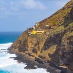
Cruzinha finish: volcanic rocks, ocean views, and a village ending
The last leg is a hike between volcanic rocks and the ocean, lasting about 2.5 hours. This is where the “workout plus pay-off” combo really hits. You’re not just walking; you’re moving along a rocky route with long sea views, and it’s the kind of terrain that keeps your attention on foot placement.
The guide takes you to Cruzinha, a small fishing village. It’s not just a finish line—it’s a change of pace. You go from exposed walking to the calmer feeling of reaching a community at sea level.
Once you reach Cruzinha, you relax with the return transfer to your accommodation. That transfer ending matters. On a difficult trail, the ability to stop dealing with transport is the difference between a trip that feels planned and one that feels chaotic.
If you’re deciding whether to add the lunch/picnic option, this is the point to be realistic: the final hike segment can feel long if you’re underfed. Fuel earlier in the day and you’ll appreciate the last views more.
What to bring for a difficult 15 km day
This is rated difficult, and the trail is described as linear with narrow parts at the beginning. You’ll want gear that helps you stay steady and comfortable for hours.
Bring:
- Decent hiking shoes with grip for steep and flat terrain
- Hat + sunscreen for sun exposure during long walking stretches
- Water (you’re told to bring it, and you should plan to use it)
- Camera with charged battery so you don’t miss key views
Also expect the day to be long enough that you may want small snack support, because snacks aren’t included and the picnic is extra. If you don’t love carrying a pack, keep it minimal: water, sun protection, and a simple snack plan.
One more “don’t skip this” detail: this hike is not recommended for those afraid of heights. That doesn’t mean you’re constantly exposed in the Hollywood sense, but given the cliffside start and steep segments, it’s enough that anxiety could ruin the experience.
Who should book this hike, and who should skip it
Book this if you want:
- A guided, route-managed hike across multiple villages
- Big views plus village walking, not just one scenic point
- A day plan with a clear end at Cruzinha and return transfer
It fits people with strong physical fitness. The tour is about 15 km total with a difficult level, so if you’re typically comfortable with long hikes and steep-ish sections, you’ll be in the right zone.
Skip it if:
- Heights make you nervous
- You’re not ready for several hours of steady walking (about 6 hours)
- You don’t like hiking on narrow starts or uneven ground
This is also a good match if your group values a knowledgeable guide who can explain what you’re seeing. One standout theme from the experience reports is the guide’s welcoming, friendly approach, plus solid context about the area—wildlife, history, and ecology were specifically mentioned. That kind of guidance turns “a hike” into “a better hike.”
Should you book this Santo Antão route?
Yes, if your idea of a great day is village-to-village walking with dramatic ocean views and you’re comfortable with a difficult hike. The biggest wins here are the structure (guided route + private transport), the scenery pacing (cliffs to valleys to a black-sand beach), and the fact that you’re not left to figure it out alone.
No, if heights worry you or if “difficult” doesn’t match your usual hiking comfort. Also think carefully if you hate the idea of extra costs for lunch/picnic and prefer tours where food is fully handled.
If you like your hikes with a plan and you’re the type who gets excited by viewpoints, this one is likely to hit the sweet spot.
FAQ
How long is the hike?
The experience is about 7 hours (approx.), with total walking time around 6 hours.
What’s the distance and elevation change?
The hike covers about 15 km, with ascent/descent of approximately 249 m.
Is pickup from my accommodation included?
Pickup is offered from several spots in Santo Antão. Private transportation is included, but an extra fee may apply if your pickup location is remote.
Is this a private tour?
Yes. It’s listed as a private tour/activity, so only your group participates.
What time does the tour start?
The start time is 8:00 am.
Is lunch included in the price?
No. Picnic lunch (on the beach) is an extra cost, and snacks are not included.
Is swimming possible at Praia d’Aranhas?
You might be able to swim depending on sea conditions at Praia d’Aranhas.
What level of fitness is required?
The tour is labeled difficult and notes that travelers should have strong physical fitness.
Is it safe for people afraid of heights?
It’s not recommended for those who are afraid of heights.
What’s the cancellation policy?
You can cancel for a full refund up to 24 hours in advance. If you cancel less than 24 hours before the start time, the amount paid is not refunded.